Nestled on the banks of one of America's most iconic waterways, Cincinnati has a rich history intertwined with the Ohio River. While the river offers breathtaking vistas, recreational opportunities, and vital economic pathways, it also presents a persistent challenge: the ever-fluctuating Ohio River level. From minor seasonal rises to historical flood surges, the city has learned through experience the critical importance of robust flood defense. This article delves into how Cincinnati protects its communities and infrastructure against the river's potential power, exploring the sophisticated systems, historical lessons, and ongoing vigilance that safeguard the Queen City.
Understanding the Dynamics of the Ohio River Level
The Ohio River's behavior is a complex interplay of natural forces, primarily influenced by snowmelt from its vast drainage basin and heavy rainfall across the Ohio Valley. These factors can rapidly elevate the Ohio River level, triggering various flood stages. Understanding these stages is crucial for public safety and preparedness:
- Minor Flood Stage: Typically begins around 52 feet in Cincinnati, at which point low-lying areas, particularly along riverfront parks and some roads, may experience initial inundation.
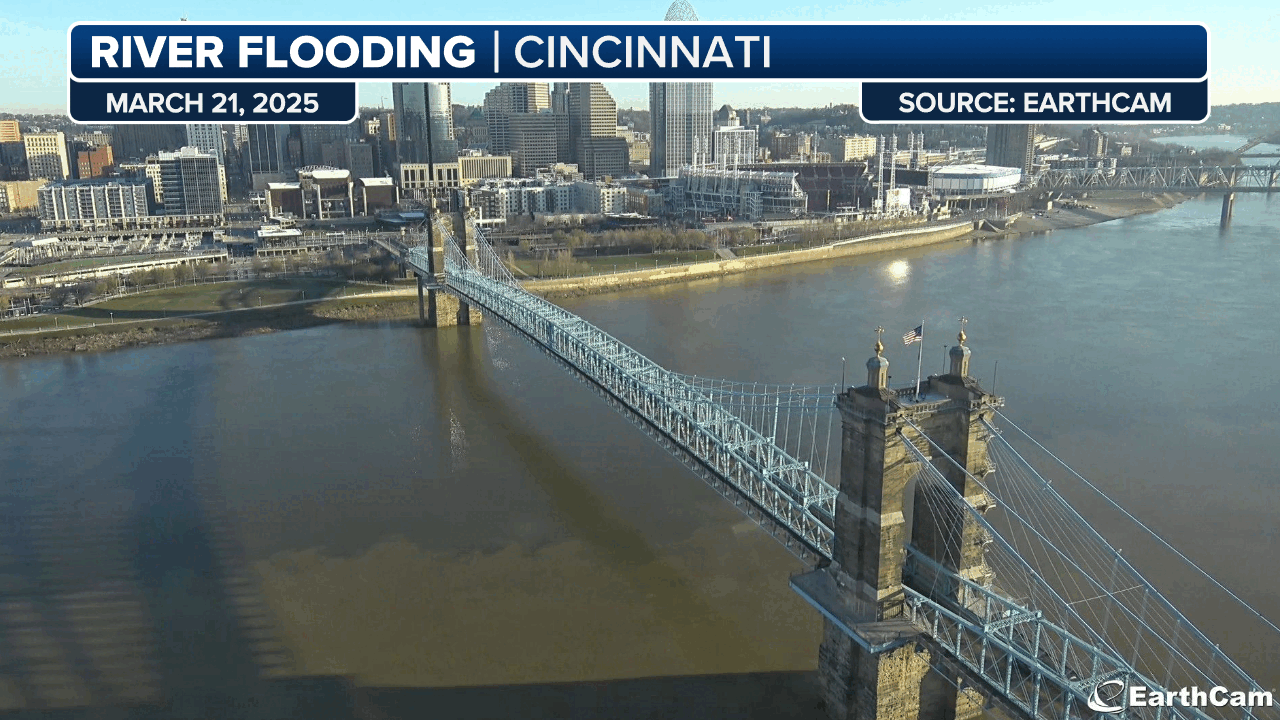
- Moderate Flood Stage: Reached when the river surpasses approximately 56 feet, leading to more widespread closures and affecting properties closer to the riverbanks. For instance, in March 2015, the river remained at a moderate flood stage, peaking at 57.72 feet – its highest since March 1997.
- Major Flood Stage: Signifies severe flooding, impacting residential and commercial areas significantly further inland. The most historically devastating event, the Great Flood of 1937, saw the Ohio River level reach an unprecedented 80 feet, a stark reminder of the river's potential.
Even in recent history, the Ohio River has shown its capacity for significant surges. Beyond the 2015 event, the river exceeded minor flood stage four times since 2000, reaching 55.9 feet in March 2011. These events highlight the continuous need for Cincinnati's comprehensive flood defense strategies, which extend beyond the immediate city limits to encompass parts of Greater Cincinnati, southern Ohio, and Northern Kentucky, where communities face similar, though sometimes more direct, impacts.
Cincinnati's Multi-Layered Flood Defense System
The relative resilience of Cincinnati and its immediate urban core during significant high-water events, such as the 2015 surge, is no accident. It's the result of decades of strategic planning, substantial investment, and the construction of a sophisticated, multi-layered flood defense system. This system combines physical infrastructure with proactive urban planning and heightened community awareness.
Physical Infrastructure: A Bulwark Against the Tides
Cincinnati's primary line of defense comes in the form of impressive engineering marvels:
- Flood Walls and Levees: These monumental structures are strategically placed along the riverfront. Following the destructive 1997 floods, significant renovations and enhancements were made to flood walls in key Northern Kentucky cities directly across the river, such as Covington and Newport. These improved defenses now offer critical protection to these vital urban centers.
- Dams and Reservoirs: Beyond the immediate riverfront, a network of dams and reservoirs in southwest Ohio plays a crucial role. These facilities manage the flow of the Ohio River's tributaries, including the Great Miami River and The Mill Creek, preventing them from contributing excess water to the main stem during heavy rainfall or snowmelt events. This upstream control is vital for mitigating the overall Ohio River level downstream.
- Fort Washington Way Flood Wall: A testament to forward-thinking urban development, a specialized flood wall was integrated into the design of Fort Washington Way during its reconstruction. This engineering feat ensures that critical transportation arteries remain protected, maintaining connectivity even during high-water events.
Proactive Planning and Community Resilience
Beyond concrete and steel, Cincinnati's flood defense incorporates intelligent urban planning and community preparedness:
- Removal of Flood-Risk Homes: A significant proactive measure involves strategically removing homes from high-risk flood zones. For instance, in 2003, FEMA purchased numerous homes in flood-prone areas like Fairfield, relocating residents and transforming these areas into green spaces or other less vulnerable uses. This prevents repeated damage and ensures long-term safety.
- Increased Awareness and Preparedness: A greater understanding of the dangers posed by the Ohio River's surges has fostered a culture of vigilance. Local news outlets, emergency services, and community organizations regularly provide updates and safety information, encouraging residents to have emergency plans and kits ready. This heightened awareness ensures that when the Ohio River level begins to rise, the community is better prepared to respond.
This comprehensive approach has proven effective. While flooding can still impact outlying areas and tributaries, the core of Cincinnati often manages to avoid catastrophic damage, even when the Ohio River level reaches major flood stage. For example, during the high-water event in March 2015, local news reported that despite the severity, flooding appeared to have been kept to a minimum within the city proper, a testament to these robust defenses.
Monitoring the Ohio River Level: Tools and Resources
Effective flood defense isn't just about physical barriers; it's also about knowledge and timely information. For Cincinnati residents and those in surrounding areas, staying informed about the Ohio River level is a critical aspect of personal and community safety. Several official sources and tools provide real-time data and predictions.
Official Data Sources: Your Go-To for Current Information
- National Weather Service (NWS) - Weather.gov: This is the primary and most reliable source for Ohio River level data and flood predictions. The NWS provides detailed hydrographs, showing current levels, historical data, and forecasts for several days out. They also issue specific flood advisories, watches, and warnings based on detailed hydrological models.
- Local News Outlets: During periods of high water, local television, radio, and online news services often provide frequent updates, interviews with emergency management officials, and visuals of affected areas.
Interpreting the Data: What to Look For
When monitoring the Ohio River level, pay attention to:
- Current Gauge Height: The most recent measurement of the river's height.
- Flood Stage Thresholds: Compare the current and predicted levels to the defined minor, moderate, and major flood stages for Cincinnati. These thresholds are critical indicators of potential impact.
- Forecasted Peaks: The predicted highest level the river is expected to reach, along with the estimated date and time. This helps in anticipating the duration of high water.
- Trend Arrows: These indicate whether the river is rising, falling, or cresting.
Practical Tips for Residents
Being informed is the first step; taking action is the next:
- Sign Up for Alerts: Many local emergency management agencies offer text or email alerts for flood warnings.
- Develop an Emergency Plan: Know evacuation routes, designate a meeting place, and ensure all family members know what to do in case of an evacuation.
- Prepare an Emergency Kit: Include essentials like water, non-perishable food, flashlights, batteries, first-aid supplies, and important documents.
- Exercise Caution Near Water: Always heed warnings from official sources regarding river safety during boating, fishing, or other water activities. "Turn around, don't drown" is a vital mantra for flooded roads.
- Secure Property: If you live in a low-lying area, move valuables to higher ground, elevate appliances if possible, and be prepared to take immediate action if floodwaters threaten your property.
While some data aggregators present river levels for general interest, always rely on official government sources like Weather.gov for critical, actionable information regarding flood safety and predictions. This ensures you have the most accurate and up-to-date information to protect yourself and your family.
Lessons from History: Major Ohio River Floods
Cincinnati's robust flood defense system is not merely a modern marvel; it is a direct consequence of hard-won lessons from historical Ohio River floods. These events, ranging from the catastrophic to the significant, have shaped the city's approach to living alongside such a powerful waterway, prompting continuous investment and adaptation.
The Great Flood of 1937: A Defining Moment
No discussion of Ohio River flooding is complete without mentioning the Great Flood of 1937. With the Ohio River level reaching an astounding 80 feet in Cincinnati, this event remains the highest ever recorded. The floodwaters submerged vast areas of the city and region, causing immense destruction, loss of life, and economic devastation. The memory of 1937 profoundly influenced subsequent urban planning, infrastructure development, and flood control policies throughout the Ohio Valley. It served as a stark, enduring reminder of the river's potential wrath and the absolute necessity of robust protective measures.
The 1997 Flood: A Catalyst for Modern Defenses
While not as severe as 1937, the 1997 flood was another pivotal event. The Ohio River level reached 64.7 feet in March 1997, causing significant damage and disruptions. Crucially, this event served as a major catalyst for renewed investment in flood defenses. It prompted extensive renovations and upgrades to existing flood walls in Northern Kentucky cities like Covington and Newport, which directly face Cincinnati across the river. It also underscored the need for integrated defenses and ongoing maintenance to prevent future calamities.
Recent Challenges: 2011 and 2015
More recent events, such as the 55.9-foot level in March 2011 and the 57.72-foot peak in March 2015, demonstrate that the threat of significant river surges remains. These instances, though successfully managed by existing infrastructure, reinforce the understanding that vigilance cannot wane. They highlight the ongoing need for:
- Continuous Monitoring: Real-time data and predictions for the Ohio River level remain critical.
- Infrastructure Maintenance: Flood walls, levees, and dams require regular inspection and upkeep to ensure their effectiveness.
- Adaptation to Climate Change: With increasing concerns about more frequent and intense rainfall events due to climate change, future strategies may need to consider even greater fluctuations in the Ohio River's height.
By learning from these historical Ohio River floods, Cincinnati has progressively strengthened its defenses, ensuring that while the river may swell, the city stands prepared.
Cincinnati's story is one of harmonious coexistence with a powerful natural force. Through a blend of ingenious engineering, strategic urban planning, and a highly informed community, the city has created a resilient shield against the potential ravages of the Ohio River. While the threat of surging Ohio River level will always be a reality, Cincinnati's comprehensive flood defense system ensures that its vibrant riverfront and cherished communities remain protected, safeguarding its rich heritage and promising future for generations to come. Continued vigilance, investment, and public awareness remain the cornerstones of this vital protection.